from the Master Plan Committee’s Tumblr site: The first BURNING QUESTION is: What are the most important natural and historic features in Milton – ones that should absolutely be retained?
Our answer to the natural feature is:
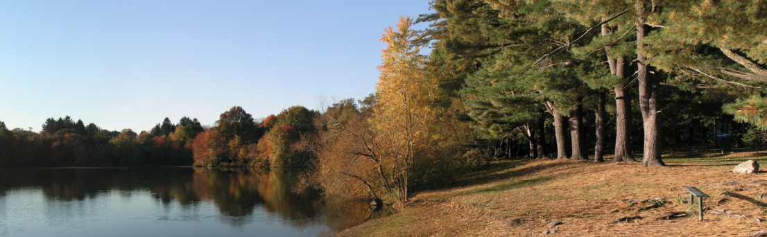
TURNER’S POND!
First, a little history — In 1989 my wife and I were looking for somewhere to live. We had a daughter and another on the way. Our apartment in north Cambridge, which was not a cold water flat but pretty close, was great for two young people trying to find their way in the world but for a family of 4 trying to find their way in the world, probably not.
Some friends invited us to stop by their home in Milton (we got out the map). Their home was not far from the Glover School on Canton Ave. We had lunch and afterwards took a walk around Turner’s Pond. It was a wonderful summer day and I thought, “This is marvelous.”
In October of that year we moved to Avalon Road and there is hardly a week that goes by without at least one walk around Turner’s. It is a small, timeless spot that absolutely must be retained.
-

- photo by Frank Schroth
-
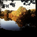
- photo by Steve Nelson
-

- photo by Frank Schroth
-
- photo by Karen Hainline
Doubtless there are spots in Milton that hold a similar place in the hearts of residents (Pope’s Pond, Milton Landing) Use the comment form below to state yours (and please use your full name).
Turner’s Pond is a wonderful and serene place in Milton, however, is it a “natural resource”?
Someone more knowledgeable that I can certainly educate us. I understood that Turner’s Pond was created as a source of fill for the construction of the SE Expressway in the ’50s or ’60s.
As one of my high school teachers often said to his students, “your education been sadly neglected”. Is that the case here? Did Turner’s Pond predate the XWay construction but was merely expanded and deepened?
Bob,
Indeed Turners Pond did predate the expressway. In fact it predates the invention of refrigeration. If my memory is correct (it was quite a while ago), the Turner family created the pond for ice harvesting, and sold ice to Milton residents so they could keep their food cold.
I’m sure there are many others who can elaborate much more…
Thanks, Rick
Bob,
I do not know much of the history. Like Rick, I had heard that ice was harvested from the pond to feed ice boxes. I also know that the residents of my street (most of whom have since passed) used to light fires around the perimeter of the pond and skate on it (what a picture that would have been). The excavation you refer to likely put an end to that as the pond became too deep to freeze over safely. Circling back to the question asked by the Master Plan Committee, I believe it is now a natural resource and definitely worth preserving. Thanks for your comments and interest.
Frank
I think all our ponds should be identified priorities for protection as well as our brooks, streams and wetlands. They are all interconnected and function as our vital watershed. From the Blue Hills, through the Harland St. dam, to Popes Pond, Pine Tree Brook, Turners Pond onto Neponset River. & Lower Mills. They fill & flow into our wet lands preventing flooding and providing habitat for all types of animals and plants. No one section can be exist alone. I love my Popes Pond !
From Milton Historical Society website:
“Early in the 1880’s Jacob A. Turner made provision for his own ice supply by using a dam of ‘Aunt Srarah’s Brook’ near the junction of Canton Avenue and Brook Road to build a pond. The old dam, a landmark for many years, was the site of the former wool works used by William Davis and others. As late as the mid 1920’s ice was still being removed and stored in sheds on the Central Avenue end of the pond.
In the 1950s and 1960s the Town acquired the two ponds which are now part of the Town of Milton park system.”
http://www.miltonhistoricalsociety.org/Sampler/
(There is a photo at that link that purports to be Turner’s Pond, but looks unrecognizable with what we know today).
It’s funny how oral histories work, and how unreliable they can be. When we first moved to Milton and started frequenting Turner’s Pond over a dozen years ago, somebody told me–and I accepted as truth until today–that Turner’s was badly polluted because it was created to hold the waste discharge from tanneries in town . . .
I agree with Malcolm. We should start planning by drawing a line around all the water resources he identified, including their jurisdictional buffer zones, and identify the entire area as an environmental protection zone. Where this zone overlays private property, the underlying zoning would still apply.
I agree with Malcolm. Our bodies of water in Milton are all connected and all worth preserving and enhancing. The Milton Brook Walk concept, linking them all, is described elsewhere on this website (thanks again, Frank). I hope to organize an initial brainstorming and get-acquainted meeting soon, inviting 10-15 folks who have already expressed interest or support of the Brook Walk. Anyone who would like to attend, please let me know.
I’m glad I asked.
I also agree with Malcolm, Pete and Jeff
Thanks Michael & Frank for the history updates.
Couple of Turner’s Pond memories…
I remember skating on the Central Ave side in the 1950’s. One child drowned trying to cross the pond on thin ice about 40 years ago.
The pond is quite deep in the middle. I believe a construction company with Milton family ties from Century Lane (Maranuchi?)that had contracts with the state for rubbish removal and building the expressway had something to do with the pond’s depth.
I worked for the Milton Park Department in the summer of1967. The MPD with state environmental guidance removed hundreds of pounds of fish so that Turner’s could be stocked with trout. I recall “netting” a 7 pound bass.
A lesson for all is that the Neponset River estuary system involves most of the waterways in Milton.
I think the second step is to identify all the park and open space land. This should be identified as public parks and open space, privately owned protected open space, and land protected through conservation restrictions.
I believe the maps displayed at the Master Plan forum were quite inaccurate in these areas.
I moved to Milton in 1990 because I fell in love with Houghton’s pond. I used to come to Milton from Somerville in the late 80’s with my wife just to walk around the Blue Hills, and the pond. When the opportunity presented it self we purchased our home, and I am falling in love with Milton ever since. I live basically 5 minute’s walk from Popes pond, 15 minutes from Turner’s pond, and just a minute from the Pine Tree Brook, and I agree with Malcom as well, especially because we need to consider the balance between protecting and preserving what we have, with the notion that we also need to be able to enjoy what we have.
The Pine Tree Brook path is one very important step to allow the residents of this town to enjoy the fantastic nature of Milton, while taking a walk with your baby, or go for a run. Today I have to drive all the way to the Milton T station so I can park and go for a run on the bike path.
Another point is that people in town don’t know, or appreciate the beauty of the Neponset river. As someone that has spent a lot of time on the river, I can to tell you that it is a real gem. Canoeing, kayaking, rowing, and so much more is accessible here, on our own little spot on the river.
Please keep the conversation going.